Just as we can view Maratha documents today, why don't we see maps of their territories or military campaigns from that era? Were such maps never created in the first place? This is a question that has always intrigued me. Some historians, like Shejwalkar, have suggested—likely due to a lack of evidence—that the Marathas lacked the resources to map their kingdom's geography and did not have a precise understanding of their state's boundaries. Consequently, I hadn't really attempted to search for Maratha maps here at the British Library.
जशी मराठ्यांची कागदपत्रे आज आपल्याला पहायला मिळतात तसे त्यांच्या त्या वेळचे त्यांच्या मुलूखाचे वा स्वाऱ्यांचे नकाशे वगैरे का पहायला मिळत नाहीत - ते तसे कधी बनवले गेलेच नाहीत का? हा मला नेहेमी पडणारा प्रश्न. शेजवलकरांसारखे काही इतिहासकार (पुराव्यांच्या अभावी बहुधा!) मराठ्यांकडे त्यांच्या राज्याच्या भूगोलाची साधने उपलब्ध नव्हती - राज्यांच्या सीमांचे त्यांना नीट ज्ञान नव्हते असं म्हणतात. त्यामुळे मी मराठ्यांचे नकाशे इथे ब्रिटीश लायब्ररीत शोधायचाही फारसा प्रयत्न केला नाही.
Last week, while browsing the Blumhardt Catalogue (a catalogue that deserves a separate post of its own!), I stumbled upon entries that appeared to be maps, so I requested to see them. Initially, I was told I could view them in the 'Maps Room.' However, in the Maps Room, I was informed that since these were manuscripts, they had to be viewed in the 'Asian and African Room.' Such confusion regarding shelfmarks rarely happens at the British Library. But after being sent back and forth a couple more times, I finally asked the curators of both rooms to meet me together and clarify the situation. They apologized for the mix-up (!!), consulted with each other, and arranged for me to view the material—whatever it turned out to be—on Saturday.
मागच्या आठवड्यात ब्लूमहार्ड कॅटलॉग (ह्या कॅटलॉगबद्दल एक वेगळी पोस्ट लिहावी लागेल!) चाळताना अचानक काही नकाश्यांसारख्या वाटणाऱ्या नोंदी दिसल्या म्हणून त्या पहाण्यास मागवून घेतल्या. सुरुवातीला मला सांगण्यात आलं की मॅप्स रुममध्ये हे पहायला मिळेल. मॅप्स रुममध्ये सांगितलं की ही हस्तलिखितं आहेत त्यामुळे 'एशियन ॲंड आफ्रिकन रुम' मध्येच पहायला मिळेल. ब्रिटीश लायब्ररीत शेल्फमार्कसची अशी गडबड सहसा होत नाही. पण अशी अजून दोनदा टोलवाटोलवी झाल्यावर मी सरळ दोन्ही रुम्सच्या क्युरेटर्सना एकत्र बोलावून मला नक्की काय ते सांगा - असं सांगितलं. त्यांनी आधी ह्या गडबडीबद्दल दिलगिरी व्यक्त केली (!!), आपापसात चर्चा केली आणि मला शनिवारी हे मटेरीयल (जे काही असेल ते!) पहायला बोलावले.
I returned to the library on Saturday. The curator of the 'Asian and African Room' called me over and revealed that the material consisted of maps—hand-drawn ones, at that! Because they were on old paper, they carried 'Manuscript' shelfmarks, yet because they were maps, they also had 'Map' shelfmarks. That was the source of the confusion. She further mentioned that these maps had likely not been seen by anyone for the past 80–85 years, and I was fortunate enough to get a look at them; resolving issues with 'shelf marks' is usually not an easy task, but since work on the map collection was currently underway, the process was smoother and faster than usual.
शनिवारी मी पुन्हा लायब्ररीत गेलो. 'एशियन ॲंड आफ्रिकन रुम' च्या क्युरेटर बाईंनी मला बोलावून घेतले आणि सांगितले की हे मटेरीयल म्हणजे नकाशे आहेत आणि तेपण हातांनी काढलेले! जुन्या कागदांवर असल्याने त्यांना 'मॅन्यूस्क्रीप्टस' चे शेल्फमार्क होते आणि नकाशे असल्याने 'मॅप्स' चे ही शेल्फमार्कस होते. त्यामुळे गडबड झाली. त्या पुढे हेपण म्हणाल्या की - गेल्या ८०-८५ वर्षांत हे नकाशे कोणी पाहिलेले नसावेत आणि तुलाही नशिबानेच बघायला मिळत आहेत कारण शेल्फमार्कसची गडबड इतक्या सहज दूर होत नाही पण सध्या त्यांचे 'मॅप्स' बरोबर काम चालले आहे त्यामुळे हे काम करायला नेहेमीपेक्षा सोपं पडलं आणि लवकर झालंय.
My curiosity was now at its peak. She placed a 3-foot by 3-foot folio in my hands. Upon opening it, I discovered maps in Marathi and the Modi script. There weren't many—perhaps eight or nine sheets—but they were authentic Marathi maps. They included maps of Gwalior, Udaipur/Nathdwara, Baroda, Mathura, Ajmer, Brahmavarta, Agra, and Pratapgarh (a location in Rajasthan).
माझी उत्सुकता आता शिगेला पोहोचली होती. त्यांनी माझ्या हातात एक ३ फूट x ३ फूट फोलियो ठेवला. उघडून पहातो तर काय - आतमध्ये मराठी / मोडी नकाशे. जास्त नव्हते ८-९ कागद असतील पण अस्सल मराठी नकाशे. ह्यात ग्वाल्हेर - उदयपूर / नाथद्वारा - बडोदा - मथुरा - अजमेर - ब्रह्मावर्त - आग्रा - प्रतापगढ (राजस्थानमधील एक ठिकाण) ह्यांचे मराठी नकाशे होते.
I am sharing the map of Gwalior here. Several features stand out clearly in it.
सोबत ग्वाल्हेरच्या नकाशा देतोय. ह्यात काही गोष्टी ठळकपणे दिसतात (नकाशा मोठ्या स्वरूपात पाहण्यासाठी त्यावर क्लिक करा).
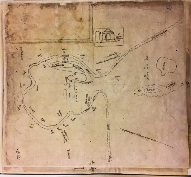
- Sarkarwada (administrative complex), the city, and the fort
- The Resident's bungalow and a notation reading "Ek-kapni astil, lashkar nahi" (Only a single company present; no full army contingent)
- Names of Sardars (nobles/commanders) such as Angre, Patankar, Nimbalkar, Hindurao, Ambuji Ghadge, Vamanrao Apte, Raoji Trimbak, and Trimbakpant Kibe
- Positions held by the Paltans (regiments) and the 'Kale Sardar'
- Jinsi artillery (heavy ordnance) and their oxen
- Rivers, wells, and streams (water sources/availability)
- सरकारवाडा, शहर, व किल्ला
- रेसिडेंटचा बंगला व 'एककपणी असतील लष्कर नाही' ही नोंद
- आंग्रे, पाटणकर, निंबाळकर, हिंदुराव, अंबुजी घाडगे, वामनराव आपटे, रावजी त्रिंबक, त्रिंबकपंत किबे ह्या सरदारांची नावे
- पलटणी व काळे सरदार ह्यांचे मोर्चे
- जिनसीच्या तोफा व त्यांचे बैल
- नदी, विहीरी व ओढे (पाण्याची परिस्थिती)
No further information regarding these maps is available in the library. There is no clue as to who drew them, when they were created, or which military campaign they pertain to. I will certainly post the other maps in due course, but for now, this evidence leaves no room for doubt: Marathi maps did exist—even if not necessarily from the Peshwa era—and Marathi rulers were indeed planning their military campaigns in a systematic manner.
ह्या नकाशांबद्दल बाकी कोणतीच माहिती लायब्ररीत उपलब्ध नाहीये. कोणी काढले - कधी काढले - कोणत्या स्वारीचे आहेत - काहीच कल्पना नाही. यथावकाश मी बाकीचे नकाशेपण पोस्ट करेनच पण सध्यातरी पेशव्यांच्या काळात का असेनात पण मराठी नकाशे अस्तित्वात होते आणि मराठी शासनकर्ते सुसूत्रपणे मोहीमा आखत होते ह्या बाबतीत ह्या पुराव्यानंतर दुमत नसावे.